
Introducing Mofi, the ultimate digital logbook solution for fishermen who want to ensure compliance with regulations and prioritise sustainability in their fishing practices.
Mofi is a cutting-edge mobile app that simplifies the process of recording fishing activities, catches, and bycatches, while also providing advanced data accuracy, traceability, and streamlined compliance processes. With Mofi, fishermen can easily register their catch information and ensure compliance with regulations, while also tracking sustainability factors such as target species, fishing methods, and ecosystem impacts.
Mofi's advanced technology replaces traditional pen and paper logbooks, offering features such as customizable forms, real-time reporting, and advanced data tracking, making it the perfect solution for fishermen looking to optimise their fishing operations, meet regulatory requirements, and prioritise sustainable fishing practices.
By using Mofi, fishermen can make informed decisions about their fishing practices, reducing the impact on the ecosystem and ensuring long-term sustainability.
Say goodbye to traditional pen and paper logbooks and hello to the future of fishing with Mofi!
|
|
|
Our app allows the administrator to control the information that will be collected per vessel. It is easily configurable with a scheme file to suit your needs.
Throughout your trip, Mofi can automatically log your geographical location, course, speed, and gear activities, ensuring that you never miss a beat.
When your vessel is too close to the border of a prohibited fishing region, you will be warned.
Mofi will assist you in remaining in compliance with the rules and avoiding any unnecessary fines.
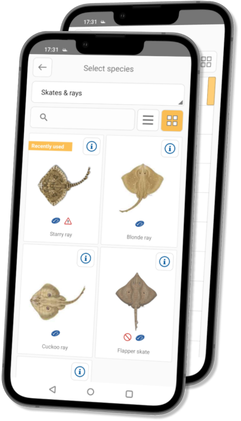
With our app, registering your catch, bycatch, and discard is now more comfortable than ever, thanks to our assisted species selection feature. You can easily register caught endangered species in collaboration with MSC.
Mofi's vessel location data is updated on-shore every 15 minutes, giving control officers an overview of all vessel positions at any given time. Immediate control actions can be taken if required.
Mofi connects to Bluetooth hardware which serves as a button to register gear activities in wet conditions where a mobile phone is less usable.
Mofi collects and stores data in the Anchor Labs database, where controllers can use the Black Box Analyzer Client to view and analyse the log data.
Mofi’s user interface can support any language, currently available in Danish, Dutch, English, German, Swedish, and Spanish.
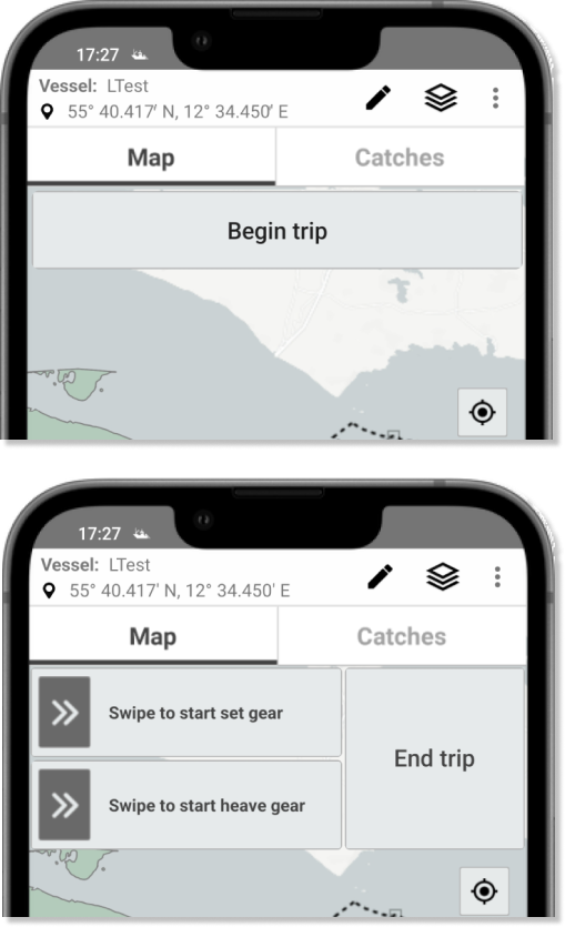
Mofi's controls were designed with fishermen in mind. Our user-friendly interface for trip and gear control tracking boasts only four buttons, so you can focus on what really matters - catching fish!
We know that time is of the essence when you're out on the water. That's why we've created an interface that's as simple as possible, so you can spend more time fishing and less time fussing with manual registries.
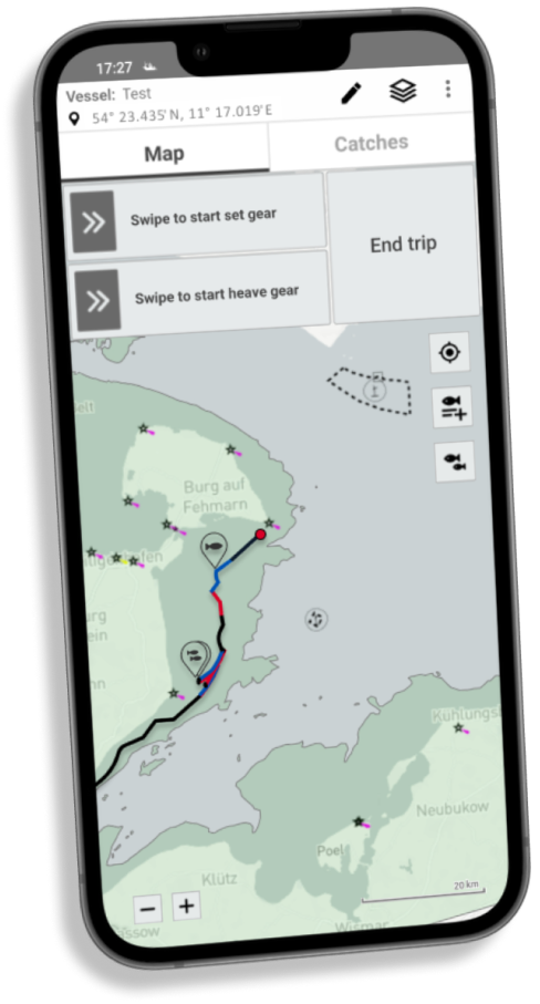
Get ready to take your fishing experience to the next level with Live Map View - the ultimate tool for tracking your fishing trip! Once you hit the water, Mofi gets to work recording position and gear activity data, so you can sit back, relax, and let us do the heavy lifting.
Our visually stunning multicolour trip path lets you see exactly where you've been - black for sailing, red for setting gear activity, and blue for heaving gear. And with a red circle indicating your current location, you'll always know where you are on the map.
But that's not all - Live Map View also allows you to visualise saved catch, discard, and bycatch positions, as well as POIs (point of interest). With detailed location data, comments, and even image files, you can keep track of all the important details of your trip.
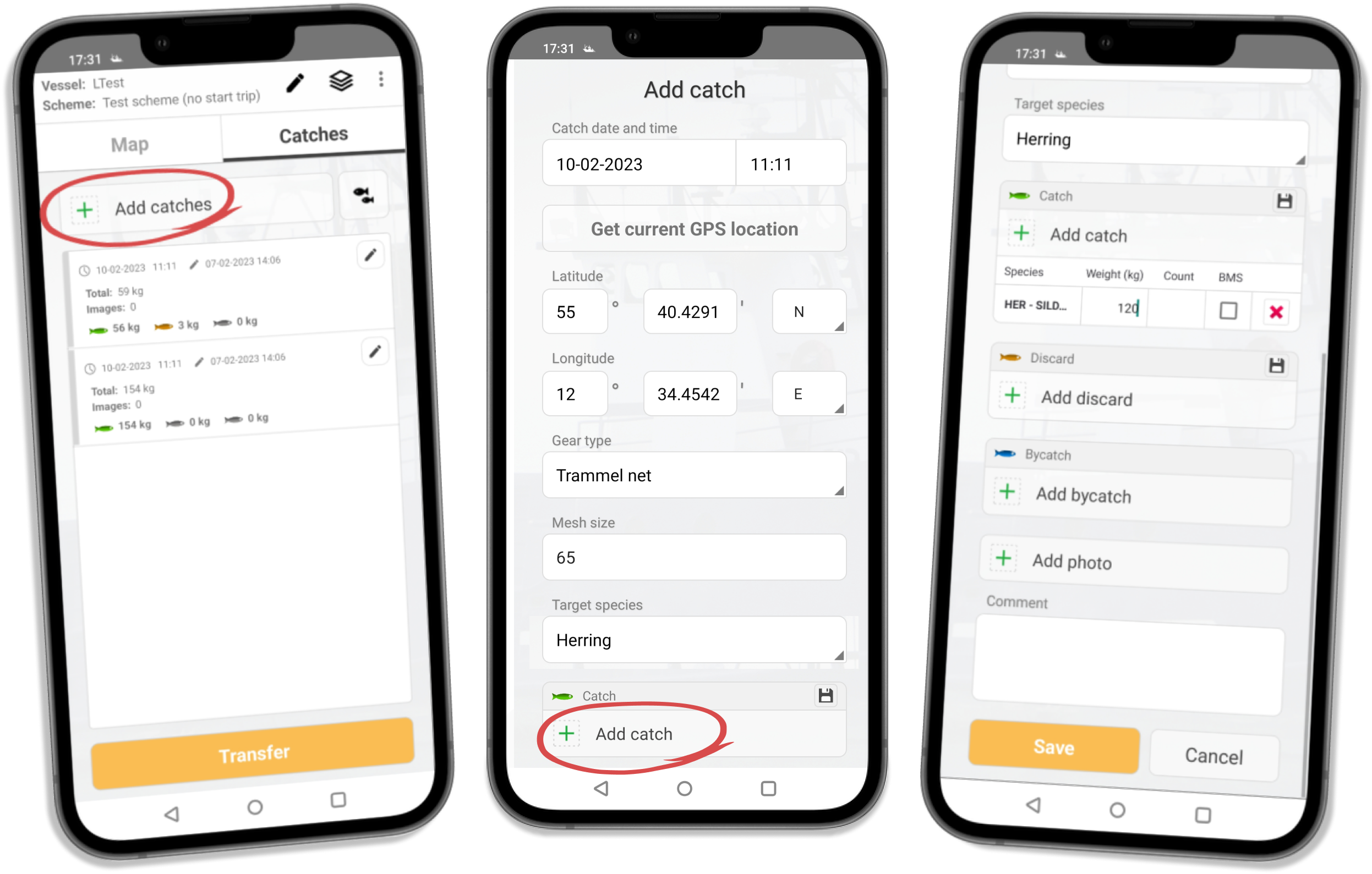
With Catch Registration, you can keep track of all your catches easily and efficiently. Mofi supports catch, discard, and bycatch (endangered species) registration forms, with customizable fields that can be added or removed by the administrator as required for each use case.
The registration process is made even easier with automatic date, time, and location values that are filled in automatically. However, you have the option to edit them manually if necessary.
Catch Registration also remembers your customizable fields such as gear type, mesh size, and target species, and automatically fills them in for later use. This makes it easier for you to reference past catches and optimise your fishing strategy for future trips.
And if you want to add some extra details to your registration form, you can also include one or more photos with a comment at the bottom of the view.
With Catch Registration, you have everything you need to keep a detailed record of your fishing catchs to confirm compliance with the fishing rules, avoiding any unnecessary fines.
The species list is displayed in a clear and concise grid or list format, complete with images, species codes, and names. You can easily search for a specific species by name or code, or filter the list by categories like mammals, birds, or rays.
By registering your catch, discard, and bycatch, you can help ensure compliance with fishing regulations and contribute to the sustainable management of our oceans.
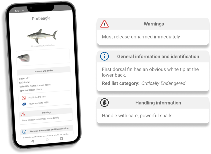
Endangered Species Overview is a powerful feature in Mofi that helps fishermen accurately identify and handle endangered species.
With our intuitive interface, you can access a detailed overview of selected species, including additional images, if available. By clicking on any image, you can view it in full-screen mode, allowing for a closer look and better identification.
By utilising the information provided on this screen, fishermen can determine how to handle a particular species if they catch it, ensuring that the species is treated with care and released back into the ocean safely.
Species' information, displayed on this view, can be easily modified or updated by administrators to fit the needs of each fishing zone.
Data Transfer is a practical and useful feature in Mofi that allows users to send gathered data to one or more endpoint locations based on their specific needs. You can choose from a variety of options, including required and optional endpoints, making it easier to transfer data to your desired destination.
We offer direct data transfer into the Black Box Analyzer ecosystem, which allows you to review and analyse your data efficiently.
With the Transfer List view, you can easily track the status of your data transfer and ensure that your data is delivered safely and securely.
Please view our data safety section for information about how we handle personal information and how it and your account can be deleted.
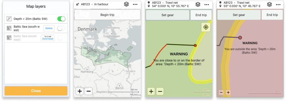
Map Layers is a valuable feature in Mofi that supports shape files for map overlays. One example of such an overlay is the green area on the map that depicts the region in German waters with a water depth of less than 20 metres. This map layer helps fishers to prove that they are fishing within the allowed area and avoid any violations of regulations.
The purpose of such a map layer is for the fishers to prove they are fishing within the allowed area.
With the warning system in place, if a user approaches the border of the green area where fishing is permitted, a notification appears on the screen to keep them informed. If the fisher crosses the line and leaves the allowed area, a red full-screen message is displayed on the screen, alerting the user that they are now outside the area.
At Anchor Lab, we understand the importance of staying within the allowed fishing area to comply with regulations, prevent any legal issues, and contribute to sustainable fishing. That's why we've included the Map Layers feature to help fishers to navigate and fish with confidence.
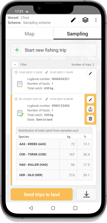
The latest addition to Mofi app is the Catch Composition Registry, better known as the sampling app, designed for pelagic fisheries to more easily assess their catch composition.
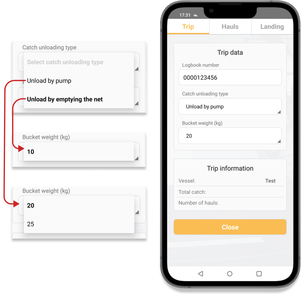
Mofi allows users to easily input catch unloading type and bucket weight on a user-friendly interface. Based on this data, Mofi automatically generates a custom Samples page, streamlining the process for the user.
For this specific example, to comply with regulations, the logbook number associated with the electronic logbook registry is required and can be easily provided in the Trip view.
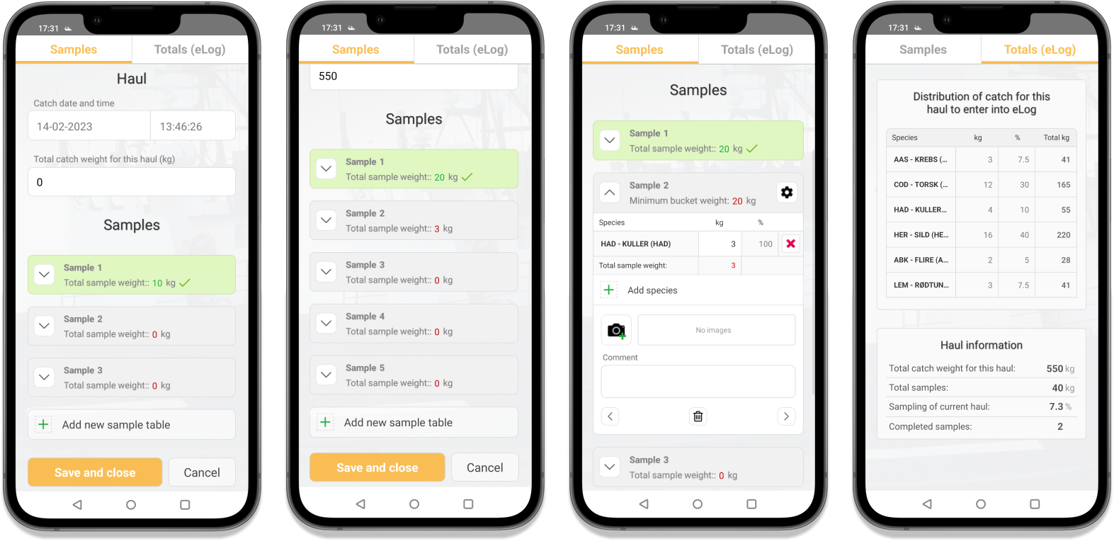
The Samples view in Mofi is designed to simplify the process of recording catch data for fishers. The Samples view in Mofi is designed to simplify the process of recording catch data for fishers.
The view also displays the minimum number of samples required for each haul and the minimum required weight for each sample. The completion status of each sample is clearly displayed through colour and icon indicators. While adding image files and comments is optional, it can provide additional information about the catch.
Additionally, the eLog view provides a catch distribution table and values required for electronic logbook entries, giving users a general catch data overview.